

On November 17th, a rare late-fall storm chasing opportunity presented itself locally as a powerful storm system moved into the Midwest. This event was forecast nearly a week in advance to effect portions of central Illinois and points east. I originally had to work on this day, but that changed on this particular morning. After seeing consistently the weather models for many days indicating a legit tornado outbreak very close to home across central Illinois I decided to call-off work on this day. It indeed appeared Peoria, IL by late morning would be in the cross-hairs of a tornado outbreak. I headed out around 9:00am to position just east of the Illinois River due to incredibly fast storm speeds (60+mph) thanks to the potent jet stream aloft that was expected. My target for the day ended up being Peoria, IL where I thought storm initiation would begin by mid morning. It was an eerie feeling leaving my apartment that morning because my gut told me this would be a "close-call" today somewhere nearby. It felt like an April morning, but it was November and that's a recipe usually for severe weather and sometimes tornadoes. Up to this point, I never had that feeling before a storm chase that I had to worry about my apartment being in the "target". Anyhow, after getting the "green-light" to chase from work I headed quickly out by 9:00am on I-74 to setup along the interstate to keep up with the fast storm motions. I found a good spot just east of the Illinois River outside Goodfield, IL with good Internet access and road options. I sat for an hour realizing I was in a very good spot. This area featured 2,000J/kg of CAPE, 0-6km shear at 60kts, a moist boundary-layer with dew points near 65°F, a supercell composite of 12, and even a significant tornado parameter approaching 4. At this point, it was just a matter of time before the weather would get interesting. By 11:00am, storm initiation was already beginning just to my west along the Illinois River. Storms quickly began to explode and organize shortly thereafter. I watched on radar for a little while waiting for the right storm to go after. At first storms struggled to get organized and were "lining out" to my west. The tail end charlie cell however, near the end of the line seemed to be getting better organized. The increasing lift allowed this cell to quickly begin rotating over just a few scans and strongly as well near Pekin, IL. At this point, I knew it was just a matter of time so I headed north to intercept and catch this supercell as it passed to my northwest. The fast storm speeds are always a pain on these type of chase days as you usually get a "one and done" opportunity which can be quite frustrating. I chose a more cautious approach positioning farther east of Washington, IL hoping to use I-39 to my advantage to keep up. This storm quickly became a long-track supercell and tornado. The first tornado touched down near Pekin, IL, but became quite destructive as it approached Washington, IL. I caught up to this supercell and tornado as it had already devastated Washington, IL and it was becoming rain-wrapped as it crossed I-39 near Minonk, IL as it took out some power lines along the interstate. Debris was still falling from the air and at this point I pulled off the interstate to snap a few photos staying back to be safe as the hook passed about a mile and a half ahead of me. It was a quick visual as this supercell and tornado was racing off to the northeast at 60mph making keeping up nearly impossible. At this time, I decided to head back knowing I couldn't keep up with it as it headed northeast. I managed to get home by early afternoon to review the event and watch the ongoing tornado outbreak in Indiana as well from home. It was a crazy local chase to say the least only traveling less than an hour from home. It was really unfortunate to see the destruction left behind especially in Washington, IL so close to home. I've added a few quick photos I shot from the brief, but rewarding late-fall storm chase below:

in the distance at around 11:00am...


you can see debris and corn husks (left) being sucked
up into this destructive supercell...

point is wrapped in the rain just to my north near Minonk, IL


ahead of me realizing their was a tornado in that mess...


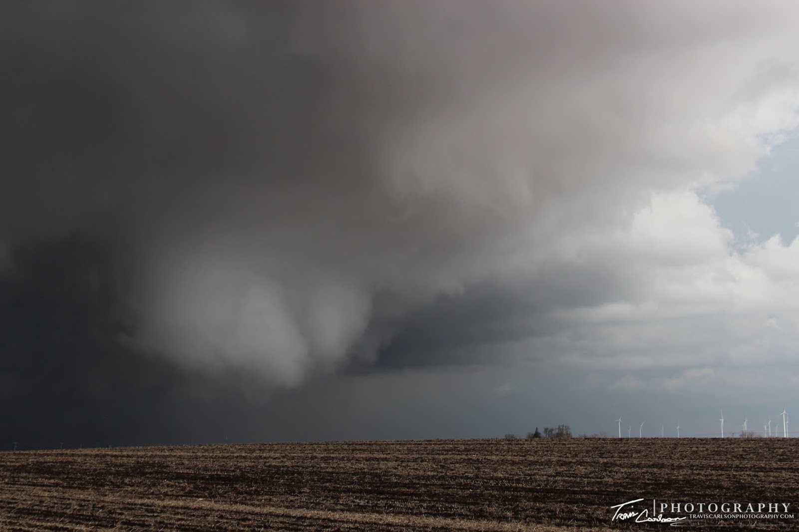


as the circulation really tightens here...


right here as it would have been great!


funnel near a wind farm...


heads quickly off to the northeast!
That will wrap up this post regarding this storm chase. Storm reports from this tornado outbreak can be found here. Here's also a nice write-up regarding the tornado outbreak from the NWS (ILX) here. This ended up being the latest to-date that I saw a tornado in a calendar year (November). It also was the earliest in the day I've ever seen a tornado to-date (11:30am). This will be one storm chase I'm sure I won't ever forget since it was so close to home. On another note, I've been hard at work over the last couple of months working on some side projects as typical over the winter months. I'll update once again when some photography opportunities presented themselves however...